THE SURVEY INFRASTRUCTURE v1.0

Survey Management
Without the Noise.

Agniforge Access is a secure B2B ecosystem designed to eliminate follow-up calls, data loss, and technical uncertainty.

Dashboard Preview
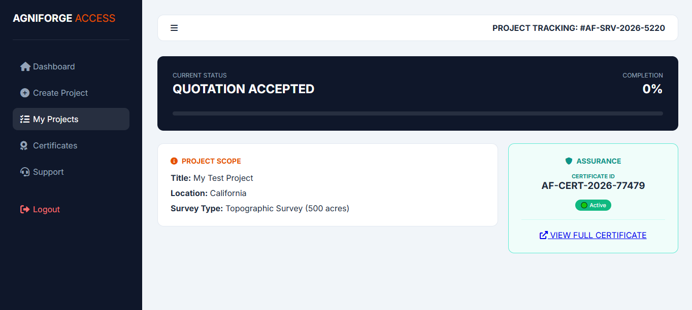
LIVE PROJECT TRACKING ENABLED
• ZERO SETUP COST • 24-48 HOUR ONBOARDING • 100% DATA SOVEREIGNTY • CERTIFIED ASSURANCE • REAL-TIME MILESTONES • ZERO HIDDEN FEES •

Why Switch to Access?

The difference between traditional surveying and Agniforge Infrastructure.

Traditional Method

  • Constant follow-up calls for status.
  • Data shared via expired links (WeTransfer).
  • No formal technical guarantee.
  • Fragmented reports and KML files.

Agniforge Access

  • Real-time Dashboard (No calls needed).
  • Lifetime Encrypted Data Vault.
  • Digital Certificate of Assurance.
  • Unified Project Timeline & History.

The 5 Pillars of Confidence

Immutable guarantees backed by our Technical SLA.

Guaranteed Closure

We take full ownership of site challenges until delivery.

Free Re-Survey

Technical errors? We re-survey the site at zero cost to you.

Data Control

Your assets are encrypted and accessible only by you.

100% Refund

Failure to deliver scope results in a complete refund.

SLA Precision

Guaranteed technical accuracy as per project standards.

Technical Authority

Geological Case Studies

Analyzing technical solutions for complex geospatial requirements. From maintaining 5cm GSD accuracy in undulated hilly terrains to extracting precise Digital Terrain Models (DTM) through dense vegetative forest canopies using advanced LiDAR technology.

Our technical logs document the geological hurdles overcome and the sensing methodologies applied to ensure data integrity for industrial-grade assessments.

ACCESS CASE STUDY ARCHIVE

Technical Competencies

High-Altitude Solar Topographic Analysis & Contouring.

Multi-Layer Vegetation Penetration & Ground Point Extraction.

Precision Volumetric Assessment for Mining & Earthwork.

Operational Scale

Project Portfolio

Documenting our large-scale survey operations across diverse industrial sectors. We provide high-precision geospatial data for complex infrastructure assets.

20,00,000+

Acres Surveyed

Topographic mapping for large-scale renewable and infrastructure projects.

150+

Strategic Locations

Executing geospatial operations across challenging national terrains.

99.9%

Operational Uptime

Consistently adhering to technical SLAs and delivery timelines.

VIEW COMPREHENSIVE PROJECT LIST

Ready to Secure Your Survey?

Onboard your organization today and experience industrial-grade transparency.

CREATE FREE ACCOUNT
Secured with AES-256 Bit Encryption